Treasures of the Orient
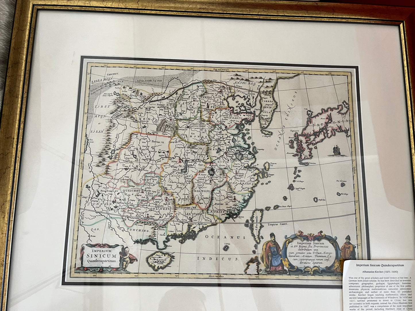
Imperium Sinicum Quindecupartitum - Kircher 1667 (Map of China)
Imperium Sinicum Quindecupartitum - Kircher 1667 (Map of China)
Imperium Sinicum Quindecupartitum (The Empire of China in Fifteen Parts)
Drawn by: Athanasius Kircher (based on the surveys of Martino Martini)
Published in: Amsterdam by Jacob van Meurs
Year: 1667 (First Edition)
From: China Monumentis, qua sacris qua profanis... Illustrata (commonly known as China Illustrata)
Condition: Fine copperplate engraving with outline color; featured in an ornate gold-gilded frame.
A Landmark of 17th-Century Sinology
This spectacular 1667 map by the legendary Jesuit polymath Athanasius Kircher is widely regarded as one of the most important European depictions of China from the early Qing Dynasty. Although Kircher never reached China himself, his China Illustrata became the definitive 17th-century encyclopedia on the region, synthesizing the firsthand reports of Jesuit missionaries into a single, masterful visual record.
The Martini Influence & Geographic Precision
The map is a refined adaptation of the groundbreaking work by Father Martino Martini, who spent years traveling through the Chinese interior (1643–1650).
Provincial Detail: As the title suggests, the map correctly identifies the fifteen provinces of the Ming and early Qing administrations, marking a massive leap forward in European accuracy regarding Chinese internal boundaries.
- Iconic Landmarks: The Great Wall is graphically depicted along the northern frontier, and the Gobi Desert is illustrated with shifting dunes. The map also traces the vital inland trade route connecting Canton (Guangzhou) to Peking (Beijing).
- Japan and Korea: Korea is shown as a peninsula (correcting earlier "island" theories), while Japan appears in its distinctive 17th-century "arc" shape, reflecting the most current nautical data available to the Dutch publishers in Amsterdam.
The "Superior" Edition
This specific example is the more prestigious and sought-after of the two versions produced for Kircher’s work. It is distinguished by its highly decorative cartouches:
Indigenous Figures: The lower-right cartouche is flanked by two indigenous Chinese men in traditional attire, adding an ethnographic dimension to the map.
Baroque Elegance: The elaborate title cartouche in the lower-left is supported by cherubs and floral swags, a hallmark of the high-baroque aesthetic favored by Amsterdam’s elite publishers.
A Scholar’s Masterpiece
Athanasius Kircher, the "Master of a Hundred Arts," created this map to illustrate the interconnectedness of global civilizations. For the modern collector, this piece represents the exact moment when the "Forbidden Kingdom" was first truly revealed to the Western world through the combined efforts of Jesuit science and Dutch engraving.