Treasures of the Orient
Aegean sea & Crete - Wells 1700
Aegean sea & Crete - Wells 1700
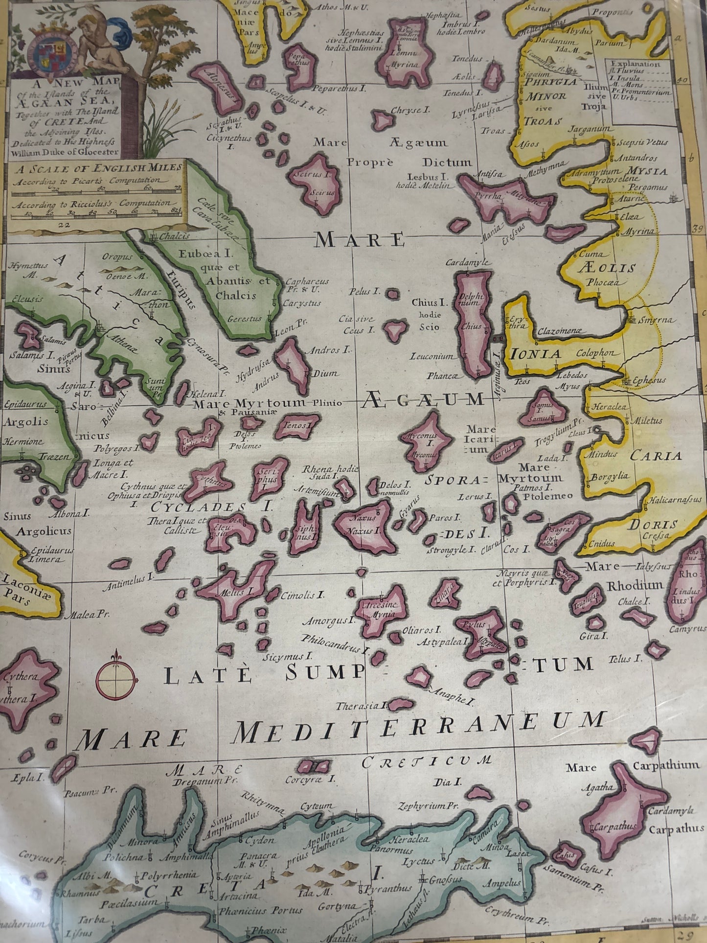
Wells’s Map of the Aegean Islands and Crete (1700)
Title: A New Map of the Islands of the Aegean Sea, Together with the Island of Crete, and the Adjoining Isles.
Cartographer: Edward Wells
Origin: Oxford / London, United Kingdom
Date: 1700
Technique: Copperplate engraving with original hand-colouring
The Narrative: A Classical Education in Cartography
This map tells the story of the English fascination with the "Cradle of Civilization" at the turn of the 18th century. Like the map of Africa you have from the same series, this was designed by the Oxford scholar Edward Wells for the education of Prince William, Duke of Gloucester. Because its primary purpose was instruction, the map eschews the cluttered decorative elements of many contemporary Dutch maps in favor of a clean, academic layout that emphasizes clarity and historical literacy.
It presents the Aegean Sea—the Mare Aegaeum—as a bridge between the classical worlds of Greece (to the west) and Asia Minor (to the east). The map meticulously plots the Cyclades, the Sporades, and the massive anchor of Crete at the bottom. It is a snapshot of how the English aristocracy studied the geography of the ancient myths and history that formed the backbone of a gentleman's education.
Chronicles of the Map
-
Royal Pedigree: The upper-left corner features a handsome dedication cartouche to Prince William, son of the future Queen Anne. The royal coat of arms adds a layer of aristocratic prestige that is highly valued by collectors of English maps.
-
Classical Nomenclature: Wells uses Latinized names for the seas and islands (e.g., Mare Myrtoum, Euboea I.), reflecting the 18th-century obsession with the Greco-Roman past.
-
Dual Scale of Miles: In a nod to the shifting scientific standards of the era, Wells provides two different scales of English miles—one "According to Picart’s Computation" and one "According to Ricciolus’s Computation"—showing the map's roots in contemporary academic debate.
-
Vibrant Hand-Colouring: The pink and yellow washes used to highlight the various island chains and coastal regions (like Ionia, Caria, and Doris) make this an exceptionally bright and decorative piece for display.