Treasures of the Orient
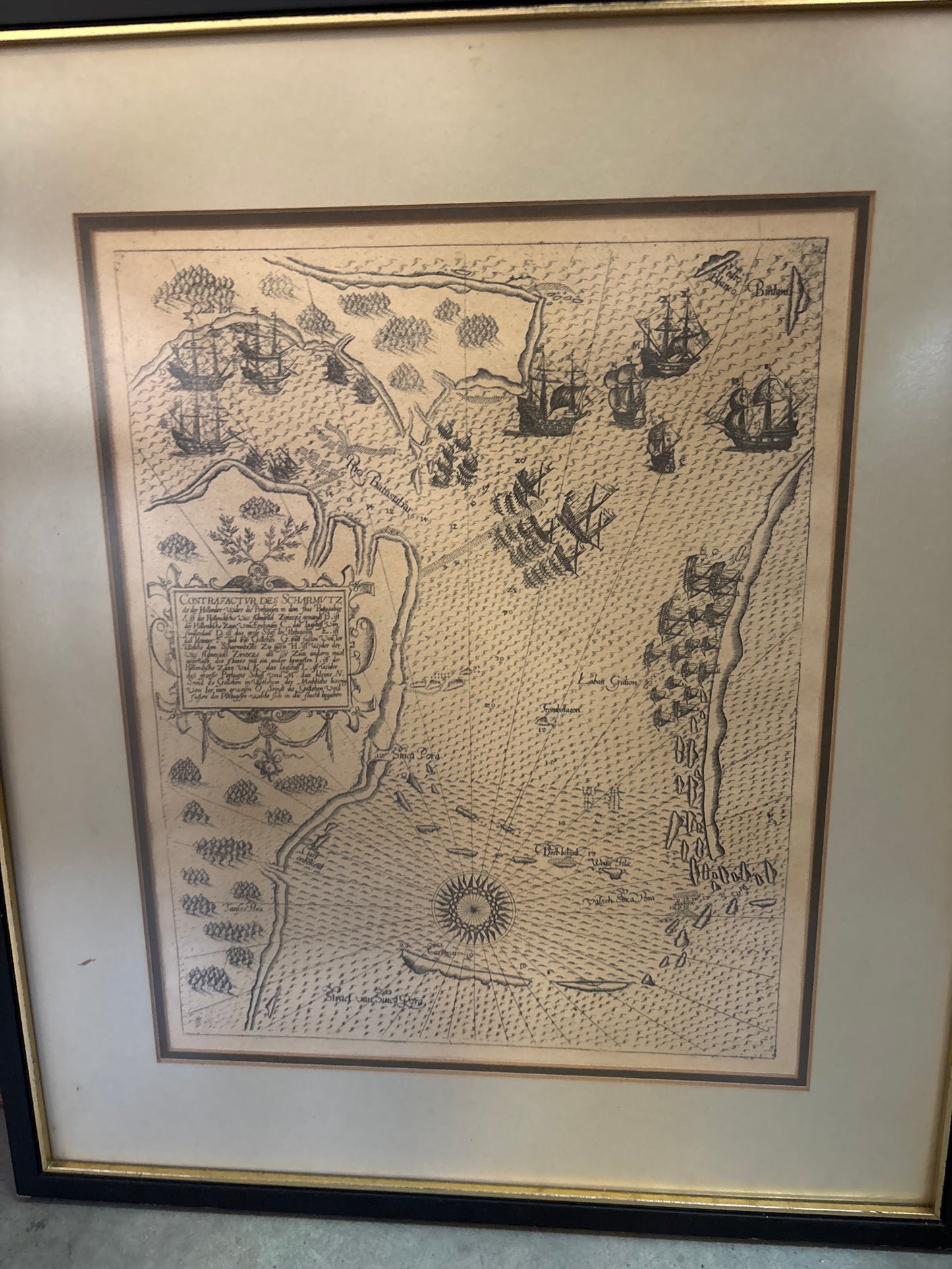
Contrafactur des Scharmutz els der Holander - De Bry 1603
Contrafactur des Scharmutz els der Holander - De Bry 1603
Contrafactur des Scharmützels der Holländer (The Dutch Skirmish)
Drawn/Engraved by: Johann Israel de Bry & Johann Theodor de Bry
Published in: Frankfurt
Year: 1603
From: Indiae Orientalis (Part VI: The Voyages of Pieter de Marees and others)
Not coloured, framed
The Earliest Close-Up Map of Singapore
For a Singaporean collector, this is arguably one of the most significant historical documents of the early 17th century. This 1603 engraving is celebrated as the earliest known map to provide a detailed, close-up view of Singapore's coastline. Rather than a distant island on a regional chart, "Sinca Pora" is shown here as the central stage for a major naval confrontation.
The 1603 Naval Battle of Changi
The "skirmish" (Scharmützel) depicted is actually a decisive naval battle fought between the 6th and 11th of October, 1603. It took place off the southeastern coast of Singapore, specifically in the waters off Changi Point and the mouth of the Johor River.
- The Conflict: A Dutch fleet under Vice-Admiral Jacob Pietersz van Enkhuysen arrived to break a Portuguese blockade of the Johor River.
- The Outcome: The Dutch, allied with the Johor Sultanate, crushed the Portuguese armada. This victory was a turning point that shifted the balance of power in Southeast Asia, cementing the Dutch-Johor alliance that would eventually lead to the fall of Portuguese Malacca in 1641.
Geographic Landmarks of Pre-Colonial Singapore
Despite being over 400 years old, several familiar landmarks are clearly identifiable on this chart:
- Sinca Pora (Singapore): Marked clearly along the southern coast, showing a reasonably accurate outline from Tuas to Changi.
- Rio Batasubar (Johor River): The site of the primary blockade and naval maneuvers.
- Pedro Blanca (Pedra Branca): The famous white rock and waypoint for mariners is distinctly marked.
- Pulau Ubin & Carimon: Modern-day Pulau Ubin and the Karimun Islands (Carimon) are visible, used as strategic landmarks during the battle.
- Straet van Sinca Pora: The "Straits of Singapore" are prominently labeled, capturing the area long before it became the global port we know today.
This map represents the exact moment Singapore's strategic location first drew the intense, violent focus of global empires.