Treasures of the Orient
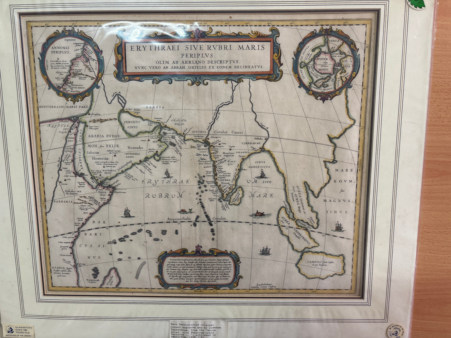
Erythraei sive Rubri Maris Periplus - Janssonius c.1650
Erythraei sive Rubri Maris Periplus - Janssonius c.1650
Title: Erythraei Sive Rubri Maris Periplus
Cartographer: Johannes Janssonius
Origin: Amsterdam, Netherlands
Date: c. 1650
Technique: Copperplate engraving with original hand-colouring
The Narrative: The Dutch Golden Age Reimagines Antiquity
By the mid-1600s, Amsterdam had become the world’s warehouse for maps. While Dutch merchants were physically dominating the spice trade in the East Indies, their cartographers, like Johannes Janssonius, were obsessed with the origins of these routes. This map tells the story of the Periplus of the Erythraean Sea through the lens of a superpower at its peak.
Janssonius took the classical geography of the 1st century and rendered it with the technical precision of the 17th. It is a map that speaks of continuity; it suggests that the same monsoons and currents that carried Roman galleys were now carrying Dutch East Indiamen. It is a visual bridge between the ancient Mediterranean world and the modern maritime empire of the VOC.
Chronicles of the Map
-
The Myth of the Golden Chersonese: Like the great maps before it, this work labels the Malay Peninsula as the Aurea Chersonesus. For Janssonius’s audience, this was more than a label—it was a justification for their presence in Southeast Asia. They saw themselves as the rightful heirs to the legendary gold trade of the ancients.
-
A Sea of Monsters and History: The Indian Ocean (then called the Erythraeum Mare) is depicted here not just as a body of water, but as a theater of history. The map meticulously plots the coastal stations of the ancient spice trade, from the frankincense ports of Arabia to the ivory coasts of "Barbaria" (East Africa).
-
The Janssonius Aesthetic: Unlike earlier Renaissance versions, Janssonius’s work is characterized by the "Dutch high style." Note the delicate stippling in the sea and the elegant, restrained cartouches. It reflects a shift from the bold, chunky lines of the 1500s to a more refined, scientific elegance.
-
The "Two Worlds" Comparison: The circular insets at the top perform a vital narrative function: they show the world of the Roman Emperor Augustus side-by-side with the 17th-century globe. It is a subtle boast, reminding the viewer that while the ancients were great, the Dutch have now mapped the entire world.