Treasures of the Orient
India-Transgangetica - Petri c.1858
India-Transgangetica - Petri c.1858
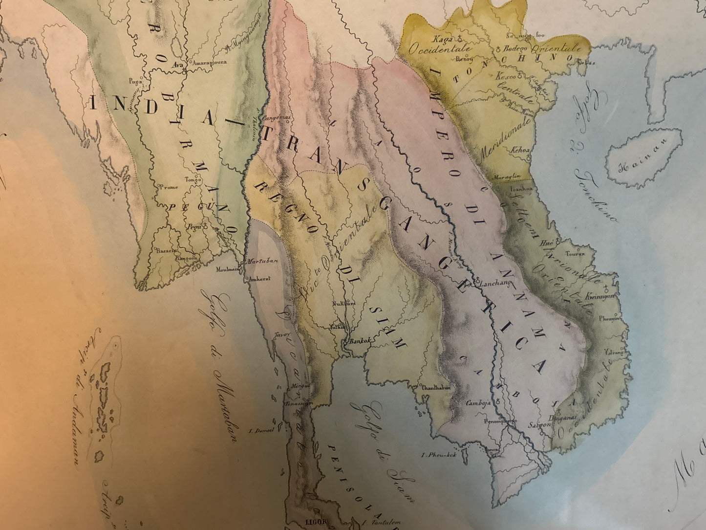
Title: Vicariati Apostolici nell’ India-Transgangetica (Tav. CXXXV)
Cartographer: G. Petri
Origin: Rome, Italy
Date: c. 1858–1859
Technique: Lithograph with original hand-colouring
A Unique Roman Perspective on Southeast Asia
This fascinating mid-19th-century map provides a rare Italian vantage point on the region historically known as India-Transgangetica (India beyond the Ganges). While most maps from this era were produced by British or French publishers to track trade and colonial expansion, this specific work was engraved in Rome to document the Apostolic Vicariates—the administrative missionary territories of the Catholic Church.
Cartographic Highlights & Fun Facts
-
The "Three Empires" of Vietnam: The map provides a detailed look at Vietnam before it was unified under French colonial rule. It labels the distinct regions of Tonchino (Tonkin), Annam, and Cochinchina, all listed under the overarching "Impero di Annam." This was published at a critical historical juncture, just as French military intervention in Indochina was beginning.
-
The Kingdom of Siam (Thailand): Thailand is prominently featured as the "Regno di Siam." During the 1850s, under the reign of King Mongkut (Rama IV), Siam was successfully navigating the pressure of Western imperialism, and this map captures the kingdom at its peak of traditional sovereignty.
-
The Malay Peninsula: The "Penisola di Malacca" is rendered with impressive detail. It lists various sultanates and coastal settlements, including the British strongholds of Singapore and Penang, though they are integrated into the broader geographical landscape of the peninsula.
-
Italian Nomenclature: Collectors often look for "out-of-area" maps like this because they offer unique place-name spellings. Seeing the South China Sea labeled as Mare della China or the Philippines as Isole Filippine adds a layer of continental European charm that isn't found on standard English charts.
-
The Tearing Down of the "Unknown": By the late 1850s, the interior of the mainland was becoming better known to Europeans. You can see the intricate river systems—the Me-Kong and the Irrawaddy—carefully engraved, reflecting the high-quality scientific data flowing back to Rome from missionary reports.
Condition & Aesthetic Appeal
The map features soft, period-correct pastel hand-colouring used to distinguish the various ecclesiastical jurisdictions. The engraving is sharp, and the wide margins (indicated by the "Tav. CXXXV" numbering) suggest it was sourced from a premium, large-format atlas.