Treasures of the Orient
Oceania - Petri c.1858
Oceania - Petri c.1858
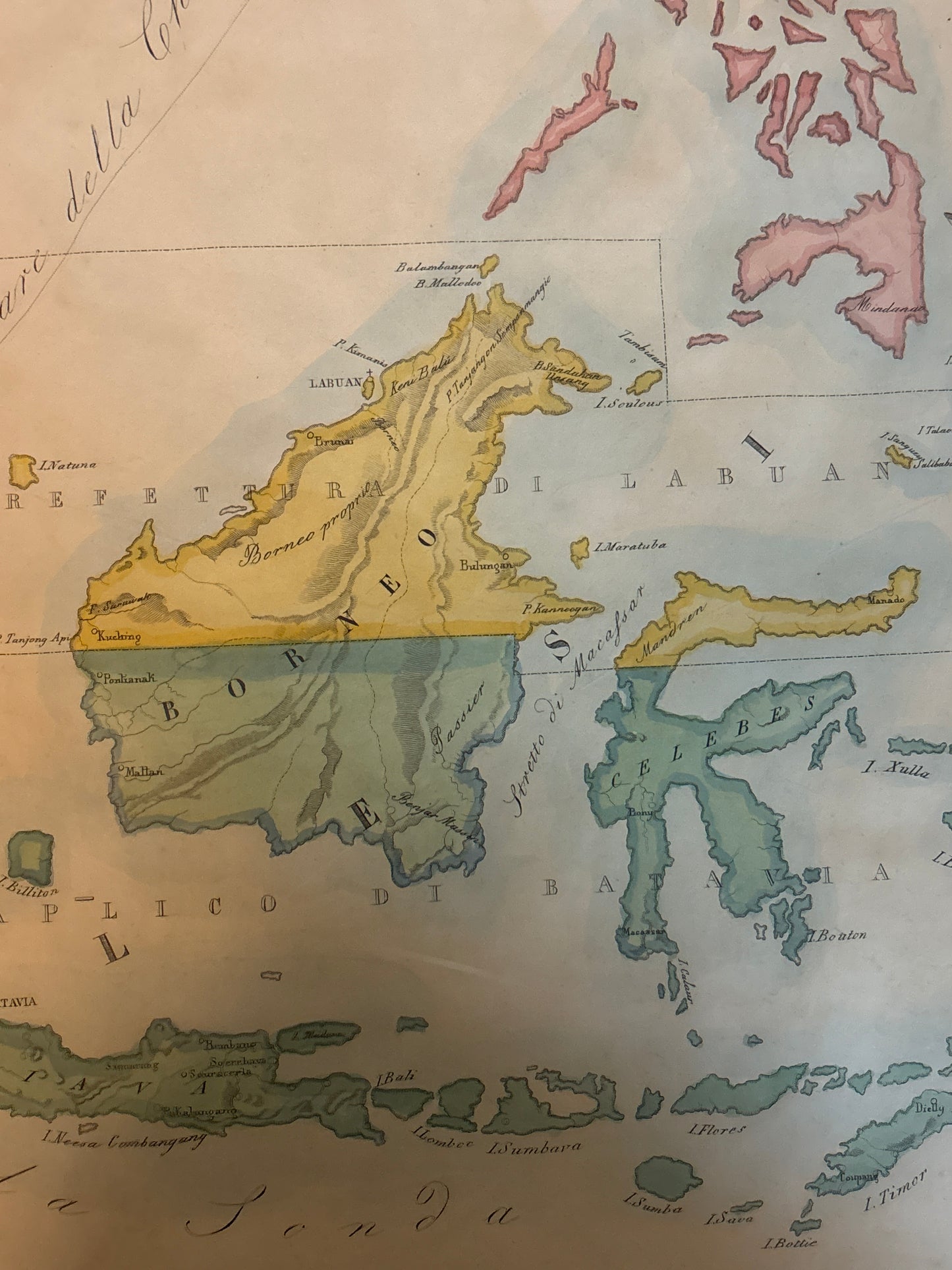
Title: Vicariato Aplico di Batavia e Prefettura di Labuan nella Oceania (Tav. CXXXVI)
Cartographer: G. Petri
Origin: Rome, Italy
Date: c. 1858–1859
Technique: Lithograph with original hand-colouring
Description: A rare and specialized map of the East Indies, this piece offers a unique perspective on the region through the lens of the mid-19th-century Catholic Church. Unlike standard mercantile maps of the era, this work delineates the Vicariate of Batavia (covering much of modern-day Indonesia) and the Prefecture of Labuan (covering Borneo and surrounding islands).
The map is finely engraved and features delicate hand-colouring that distinguishes the different ecclesiastical jurisdictions. It covers a vast area including:
-
Sumatra, Java, and Borneo: Detailed with topographical features and key coastal settlements.
-
The Philippines: Highlighted in a distinct pink hue.
-
Celebes (Sulawesi) and the Moluccas: The fabled "Spice Islands" are shown with religious boundaries.
-
Labuan: A tiny but significant British colony at the time, here serving as a missionary hub for Borneo.
Fun Facts & Collector’s Insights
-
The Labuan Connection: The "Prefecture of Labuan" was established in 1855, just a few years before this map was printed. At the time, Labuan was a strategic British base used to suppress piracy and as a coaling station. Seeing it elevated to a titular "Prefecture" on a Roman map highlights the island's brief but intense period of global importance.
-
The Language of Rome: Note the Italian nomenclature (Mari della China, Isola Filippine). During this era, Rome was the central hub for global missionary reports, and maps like this were used by the Vatican to track the expansion of the faith in "Oceania"—a term then used broadly to include Southeast Asia.
-
A Snapshot of Borneo: This map was published during the reign of the White Rajahs in Sarawak. It captures Borneo just as European influence was beginning to penetrate the deep interior of the island.
-
Scientific Precision: Despite its religious purpose, the map is geographically sophisticated for the 1850s, showing the intricate coastlines of the Indonesian archipelago with high accuracy.