Treasures of the Orient
Sumatra - Munster 1588
Sumatra - Munster 1588
Münster’s Map of Sumatra (1588)
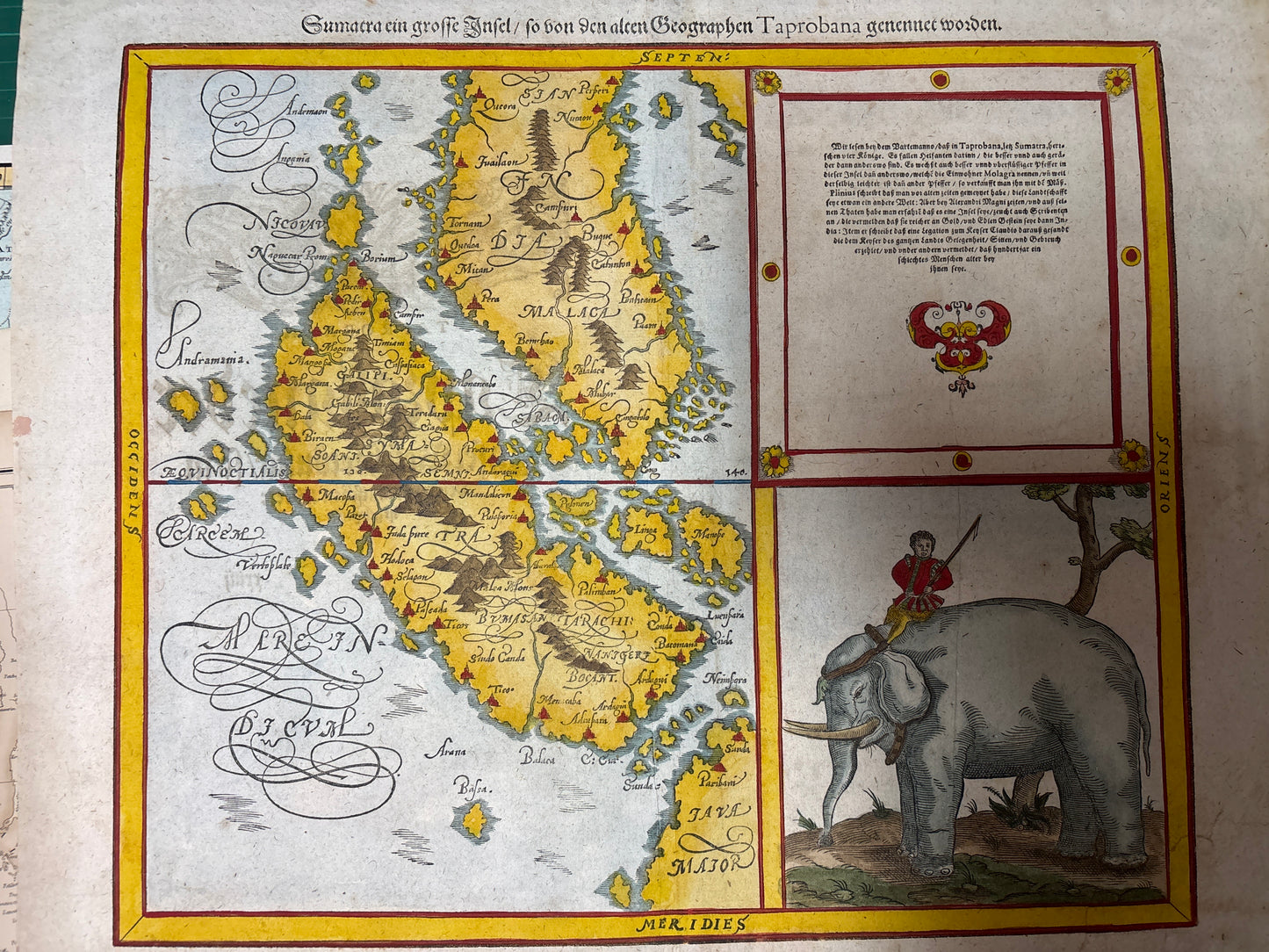
Title: Sumatra ein grosse Insel / so von den alten Geographen Taprobana genennet worden.
Cartographer: Sebastian Münster
Origin: Basel, Switzerland
Date: 1588 (The definitive expanded edition)
Technique: Woodcut with professional, vibrant hand-colouring
The Narrative: Sumatra, the Mythical "Taprobana"
This map tells the story of the great intellectual puzzle of the 16th century: the location of Taprobana. Following the ancient Greek and Roman geographers (like Pliny, mentioned in the text), Europeans struggled for decades to determine if Taprobana was Sri Lanka or Sumatra. Münster, based on the early reports of Portuguese and Venetian travelers, definitively planted his flag on the side of Sumatra.
The map is a vibrant reflection of the era when the "Orient" was first becoming a tangible reality for Europeans. It captures a Sumatra of vast mountains, ancient kingdoms (like Pase, Achem, and Palimban), and mythical dangers. Above all, it tells the story of a land of legendary wealth, particularly in Gold and Spices, which is discussed extensively in the German text. For a collector, this woodcut represents the exact moment the Indonesian archipelago began to be drawn in its correct relationship to Malaca and Java Major.
Chronicles of the Map
-
The "Cosmographia" Legacy: Sebastian Münster was the defining encyclopedist of the Reformation era. His Cosmographia, first published in 1544, was the most widely read and influential book of geography and history in 16th-century Europe.
-
The Elephant & Rider: The large woodcut in the lower right provides crucial ethnographic and natural history detail. Münster chose the Elephant as the defining symbol of Sumatra’s royal power and natural resources. It shows the beast with massive tusks being expertly handled by a local rider (mahout), emphasizing the sophistication and strength of the local cultures.
-
German Text Block: The extensive text in the upper right translates as a historical and economic report on the island. It discusses the various kingdoms, mentions ancient descriptions of the island by Venetian travelers, and confirms it is the most spice-rich and gold-wealthy island of the world.
-
The "Riau" Connection: The map accurately depicts the Riau Archipelago and the relationship between the southern tip of Malaca (the Malay Peninsula) and the northern coast of Sumatra, a vital geographic record before the VOC era.